A Long History…
The Hamilton Conservation Authority, headquartered at the western end of Lake Ontario, is the region’s largest environmental management agency. For more than 50 years it has spearheaded grassroots environmental efforts to help ensure a safe and sustainable community.
Amid a swirl of growth in the 1950s, Puslinch, East and West Flamborough, Beverly, Ancaster and Dundas petitioned the province to establish a watershed unit charged with the management of water resources. That request was approved, and the Spencer Creek Conservation Authority was founded and held its first meeting June 20, 1958, becoming one of only 12 conservation authorities in existence across the province at that time.
Sensing an urgent need to temper growth with environmental responsibility, the City of Hamilton and parts of the surrounding communities of Stoney Creek, Saltfleet, Binbrook, and Glanford decided in 1966 to join the Spencer Creek Conservation Authority. This move resulted in the creation of the Hamilton Region Conservation Authority – which has since been re-named the Hamilton Conservation Authority (HCA).
HCA is continually pursuing acquisition of new properties considered important for environmental and recreation purposes. To date, the Authority holds or manages 4,400 hectares (10,872 acres) in public trust and is responsible for approximately 56,800 hectares (140,355 acres) of watershed area.
Much of it is home to rare plants, birds and mammals whose existence depends on an environment that is not pressured by human activity.
Our comprehensive, coordinated approach to watershed management is supported by a broad range of activities which include the following:
Flood Forecasting and Flood Control
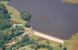
 As mandated by the province, the HCA is the lead flood forecasting and control agency in the City of Hamilton region. As part of this responsibility, the HCA operates dams at the Christie Lake and Valens Conservation Areas, and manages natural flood-control areas such as wetlands and floodplains. Additionally, the HCA reviews all applications for fill and construction within defined floodplains, and provides plan review comment to identify regulated areas floodplains and susceptible areas where development is proposed. This service plays an integral role in protecting infrastructure, industry, property and natural lands.
Environmental Planning & Watershed Management
Today, it is widely recognized that effective planning controls must be in place to prevent, or regulate new developments in or near natural areas and flood plains. The HCA provides valuable planning and technical assistance in this regard to local municipalities by recommending land use policies and reviewing development applications with potential impacts to wetlands, floodplains and watercourses. The HCA also remains an important commenting agency to the City of Hamilton, providing valuable planning and technical advice on environmental matters.
Open Space Protection and Public Use
The HCA acquires lands that are important to the environmental stability of local ecosystems. Through an aggressive acquisition program, it now owns, leases or manages 4,400 hectares of environmentally significant land, and most of it is available for public use.
Other facets of natural areas protection includes habitat restoration and rehabilitation, and monitoring the health of local streams relative to recreation, fisheries and aesthetics. Natural areas inventories and watershed studies also provide member municipalities with valuable information on ecological processes, forests, wildlife and plants. This data is vital when municipalities review proposed developments for impacts to the local environment.

To help ensure the environmental health of these privately-owned natural lands, the HCA has partnered in the Hamilton-Halton Watershed Stewardship Project (HHWSP). The HHWSP’s mandate is to provide watershed education and assistance to private landowners. This means encouraging people to take responsibility for restoring and maintaining the natural features of their properties – and in some cases, partnering in rehabilitation work. The ultimate goal is educating landowner that activities on their land, creeks and streams has a direct impact on water quality downstream and in the bays. More than 4,000 urban and rural landowners of natural areas and watercourses have been contacted and shared information about their individual roles in the protection and enhancement of wetlands, uplands and riparian areas in the two conservation authorities’ watersheds.
More than 325 landowners have made verbal agreements to consider the effects of their land management practices on the health of the watershed. These agreements cover in excess of 5,820 hectares of land, which includes more than 260 kilometres of riparian habitat and 2,700 hectares of significant natural area in both watersheds.
A logical extension of our open space protection program is the development and operation of our holdings for public recreational use. Natural lands, like the Christie Lake and Valens Conservation Areas, are developed around water management reservoirs, and combine recreational activities with habitat preservation. Another example is Fifty Point, which has been developed as an important Lake Ontario waterfront park, complete with a 320-slip marina. More passive conservation lands – such as the Dundas Valley, the Spencer Gorge/Webster’s Falls Conservation Area, and numerous wetlands – are too fragile for intensive development. These are accessible to visitors for lower impact activities.
In its role as provider of regional parks and open space opportunities, the HCA additionally manages two important regional recreation projects. Confederation Park in east Hamilton offers exciting family recreation, including one of Canada’s largest outdoor wave pool complexes and a new tube slide attraction. Westfield Heritage Village is a popular destination to experience Ontario’s past. This site also serves as a repository for the region’s collection of historical artifacts and buildings.
In addition to an extensive trail network on HCA owned/managed properties (75 kilometres), we have acquired and developed two multi-use rail trail systems: the 16-kilometre Chippawa Rail Trail, which links Hamilton to Caledonia; and the 32-kilometre Hamilton-to-Brantford Rail Trail. These rail trails, part of the national Trans Canada Trail system, facilitate commuter trips and fitness opportunities for various users and all age groups. The HCA’s Millennium Project was the development of two new trails in the area, the Lafarge 2000 Trail and the Dofasco 2000 Trail, both of which were opened in 2001. The trails extend beyond regional boundaries to connect with other communities. It is important to note that the HCA has acquired and developed some trail corridors outside its area of jurisdiction when other conservation authorities were unable to take the lead.
For more information about the HCA’s environmental and recreation programs, continue visiting our site or call 905-525-2181.
The HCA is a member of Conservation Ontario, an umbrella organization for the province’s network of 36 Conservation Authorities. Projects undertaken by the HCA are generously supported by the Hamilton Conservation Foundation.


